
Staten Island’s North Shore is preparing for four big developments and the 630-foot-tall New York Wheel, which will draw thousands of new residents and a huge influx of visitors to the sleepy industrial waterfront. But the city hasn’t spent much time trying to grapple with the borough’s longstanding infrastructure challenges, which will only worsen as the population grows.
Current projects in St. George and Stapleton promise to deliver half a million square feet of retail and over 1,200 apartments to the under-utilized shoreline serviced by the Staten Island Railway. And the city plans to rezone a 14-block swath of Bay Street—now zoned exclusively for low-density industrial uses—to encourage mixed-use residential development.
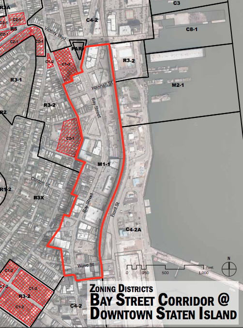
Bay Street Corridor, map by Department of City Planning
Ironstate Development’s URL Staten Island is already rising on a desolate former naval base near the Stapleton waterfront, and it will eventually include 900 apartments and 35,000 square feet of retail. The developers want to cater to young professionals, and with train stations nearby and the ferry only a mile away, they may consider moving to the largely transit-starved borough.
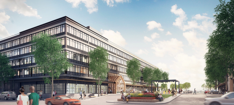
A few blocks away at 475 Bay Street, BFC Partners plans to erect an eight-story, 214-unit residential project with ground floor retail on an industrially zoned property. The site sits at the southern end of the Bay Street Corridor and will benefit from the rezoning. Since BFC built an affordable housing development nearby at 40 Prospect Street, it seems likely that this building will rent at least 20% of its units below market rate.
And then there’s the Empire Outlets, a $350 million mall and entertainment complex planned just north of the St. George Ferry Terminal. The gigantic ferris wheel would spin next door, and its developer, Rich Marin, told the Times it could attract up to 3.5 million visitors a year.
On the south side of the ferry terminal, the sprawling, mixed-use development known as Lighthouse Point will rise next to the mid-19th century Lighthouse Depot buildings. With 110 apartments, a 12-story hotel and 62,000 square feet of retail, it will be the largest of the four waterfront projects.
All of this new construction will help revitalize the most transit-accessible part of Staten Island. It’s already the slowest-growing and least densely populated borough, and the extra tax revenue and tourist dollars could be used to fix some of its underlying transit issues.
But if these buildings are successful, they’ll illuminate many of the pressing problems Staten Islanders have been complained about for years: traffic, badly maintained roads, and slow express buses.
Last year, the Center for Urban Future found that 40% of the island’s roads are “substandard,” second only to Manhattan’s. Since Islanders already have the longest commutes and the highest rates of car ownership, the city should prioritize resurfacing and reconstructing the island’s main roads. These new residential and retail projects call for thousands of parking spaces, and if they are in fact needed, the roads might as well be up to snuff.
But how will tourists, as well as these new, car-less residents, get around the island?
Traveling on public transit within Staten Island is a struggle, because the northern and western parts rely entirely on buses. Local residents told the Regional Plan Association that bus stops aren’t conveniently located, and local bus service doesn’t solve the problem of travelling from the North Shore to the South Shore. And two of the island’s express buses, X1 and X17, are the busiest and worst-performing express routes in the whole city, according to a study released in April by the City Comptroller.
Transit advocates have long fought to reactivate the North Shore Railway, an old freight and passenger rail line abandoned in 1990. But local pols prefer the cheaper option, a bus rapid transit system.
During a recent development forum hosted by the Urban Land Institute, Borough President James Oddo explained that BRT would cost $500 million. The MTA had originally put the price tag at $371 million, but after Hurricane Sandy, officials decided that the route would need to be elevated, pushing up construction costs.
When Oddo asked the city to study how the island’s infrastructure could be improved, the mayor’s administration told him that there’s a study “scheduled as part of the ULURP after everything opens up.”
“So it hits the fan, after it hits the fan, we’ll do a study,” he added. “And there’s been some pushback from folks in the administration. So we’re going to have real infrastructure challenges. But I would rather have the infrastructure challenges that are looming than a waterfront that’s underutilized.”
Subscribe to YIMBY’s daily e-mail
![]()
Follow YIMBYgram for real-time photo updates
Like YIMBY on Facebook
Follow YIMBY’s Twitter for the latest in YIMBYnews


Short answer: No, Staten Island’s infrastructure couldn’t keep up with 1990s population increases. Forget about it now.
By the way, what are the “train stations” in the plural that serve URL SI? It’s one single line running there, and as far as I know near only one station, and not that close or a very nice walk.
Just like everything else it all comes down to money.
If the Governor would not dismiss the MoveNY plan out of hand like the stubborn ass he is, there would be a dedicated revenue stream for mass transit and infrastructure.
What needs to be done with all this development is pretty simple.
1) More ferry service. With ten of thousands of people going to the Wheel and adjacent retail places, plus new residents in the area, the 30 minute headways between ferries is not going to cut it. We’re going to need more 15 and 20 minute headways between boats.
2) A massive road upgrade for Bay and Front Streets. The roads really can’t be made wider, but they can be made easier to drive on. Also, there is some consideration to making these mostly parallel roads, one way streets. That would double amount of lanes heading in either direction.
3) More SIR service. The URL development is served by the Stapleton SIR station. It is only a five minute train ride from there to the ferry, but for most of the day, the train only comes once every twenty minutes. That is just not acceptable. Like more frequent ferry service, the train headway needs to be, at the very least cut in half for most of the day. This will also help development on a smaller scale along the rest of the SIR service area.
4) A study should be done to get an idea of what it would take for a subway to go from St. George to Whitehall (with a stop in Red Hook and on Governor’s Island). There’s no doubt that the cost is at minimum several billion dollars, but it would be nice to get at least a real number and an idea of the complexity of such a project. Again, if the MoveNY plan became reality, such a project might not be such pie in the sky.
I think all of staten island’s population and commuting issues would all be fixed with a subway that connects to upper bay ridge.