

Three of the city’s top officials in transportation, housing, and economic development laid out the details of Mayor Bill de Blasio’s controversial plan to build a streetcar line – known as the Brooklyn-Queens Connector – along the waterfront from Sunset Park, Brooklyn to Astoria, Queens during a meeting with reporters on Friday.
Deputy Mayor Alicia Glen led the charge to defend the $2.5 billion plan and the decision to install more transit in some of the hottest real estate markets in Brooklyn and Queens. Besides creating a new amenity in these neighborhoods, the city plans to build two new bridges across the Gowanus Canal and Newtown Creek to support the streetcar tracks.
The bridges would have pedestrian walkways and bike lanes, said Glen, and the city had included the cost of constructing them in that $2.5 billion estimate. That might come as a relief to Greenpointers, who have been waiting years for the Department of Transportation to finish a two-way bike lane on the congested Pulaski Bridge to Long Island City.
But they didn’t discuss how the system would be flood proofed, even after admitting it would run largely in the flood plain.
Glen claimed the system would largely pay for itself through increases in property tax values. The administration’s analysis factored in a three to four percent increase in property values for the lots along the waterfront (in tax terms, their “assessed value”). And since commercial properties pay particularly high tax rates, the city’s plan to upgrade zoning for new office development near the Williamsburg waterfront seems like a smart idea.
Ultimately, officials expect to spend $30 million a year operating the new system, $20 million of which would come from fares. The remaining $10 million would come out of the city’s general fund and from the boost in property taxes.
Officials also pegged their analysis to an expected 14,000 jobs at the Brooklyn Navy Yard, where a range of industrial businesses currently employ just over 7,000 people. After analyzing potential real estate growth, they expect new construction to bring a seven percent population increase along the streetcar route. Much of that growth would come from new residential towers in Long Island City, said one planner in the meeting.
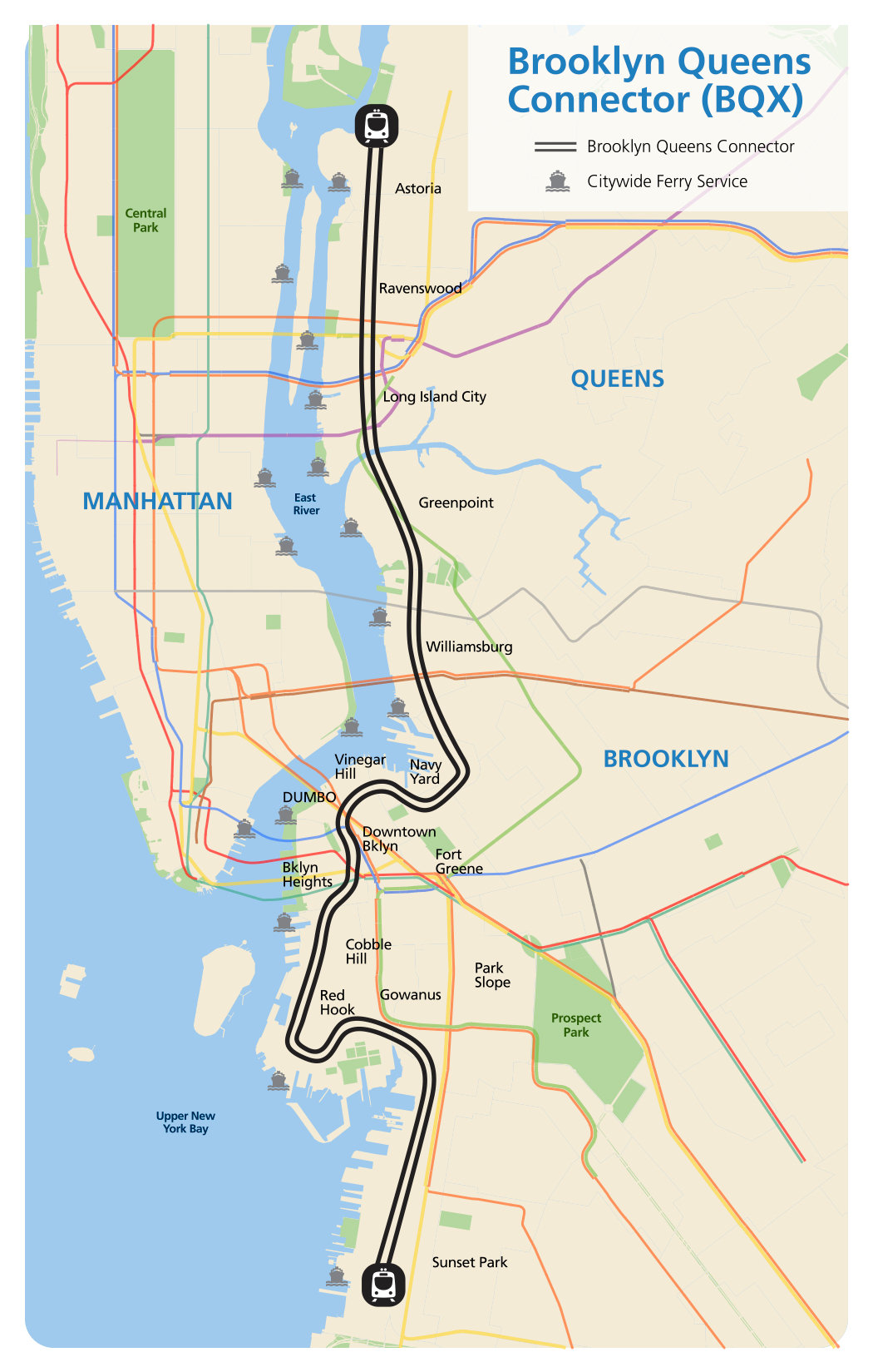
Proposed route for the Brooklyn-Queens streetcar
In the next few years, the city will create a non-profit that can issue tax exempt bonds to foot the bill for the construction. Essentially, the city will borrow the money to build out the new line and pay it back over 35 or 40 years, using increased tax revenue.
But this approach didn’t work out so well for Hudson Yards and the 7 line extension to the Far West Side. The sprawling office development has taken much longer to build than expected, and taxpayers have shelled out an additional $358.8 million to fill the hole created by missing property taxes, according to WNYC.
Marisa Torres-Springer, head of the New York City Economic Development Corporation, said they’re trying to avoid the financial setbacks that affected Hudson Yards.
However, DOT Commissioner Polly Trottenberg couldn’t say whether subway and bus riders will have a free transfer to the tram – a potential deal breaker for the route’s poorest riders. But all the officials at the meeting said the city would spend the next few years hashing out transfers and revenue sharing with the MTA.
Waterfront developers like Two Trees and Doug Steiner helped craft the initial plan for the streetcar, but de Blasio advisors pushed back against criticisms that the tram would mostly serve rich white people.
They pointed to the 40,000 NYCHA tenants who live along the proposed line (out of roughly 400,000 waterfront residents). And aides claimed their revenue plan hinged on an average $1.33 a ride, which includes discounts for students, seniors, and disabled riders. Regular fares will remain the same as a subway swipe, which is currently $2.75.
Also, the route isn’t set in stone yet, but Glen said commuters should expect to walk up to a quarter mile from the streetcar to the closest subway stop. And whether the MTA will end up cutting bus routes that run parallel to the streetcar seems to be up for debate. Earlier this week, the mayor admitted that the state-run agency may slash service for the B61, Red Hook’s most heavily traveled bus line. Trottenberg disagreed, saying there were no plans to eliminate buses in the transit-starved neighborhood.
Somewhere between 70 and 80 of the route will have a dedicated right of way, meaning that the streetcar will mostly travel in a lane that’s separate from traffic.
The city hopes to start the first round of public approvals for the project next year and break ground by 2020. The streetcar is supposed to be up and running in 2024, and planners expect 49,000 commuters to ride the rails by 2035.
Update: This piece has been updated to reflect the correct number of projected jobs at the Navy Yard and the expected operating cost of the streetcar system.
Subscribe to the YIMBY newsletter for weekly updates on New York’s top projects
Subscribe to YIMBY’s daily e-mail
![]()
Follow YIMBYgram for real-time photo updates
Like YIMBY on Facebook
Follow YIMBY’s Twitter for the latest in YIMBYnews
$2.5 billion estimate.!!!!!!!!!
How about doing all that construction and using buses that can go around floods.
How much would that cost?
Total waste of tax dollars. $2.5B = $156,250,000.00/mile = $29,592.80/foot. Modern buses are cheaper and offer more flexible routing options.
I think the closest subway stop is the smith 9th street stop on the G/F line…
One double parked car and the whole system is down. I’ve driven those streets – there is no room for rich man toys.
The only profitable street cars have been those on dedicated non-vehicular trafficked lines such as the Newark Subway. In other cities light rail hits, vehicles, pedestrians, bicyclist, and pedestrians with fatal outcomes.
The only way this proposal makes cent$ is to run the Astoria end to LaGuardia Airport and the Sunset Park end over the Verazano Bridge to Staten Island and down it’s north shore to Tottenville.
First they should test the concept of the line by resuming trolley (light rail) service over the 59th Street Bridge where the once ran until 1957.
This is ridiculous.