
Late last month, the de Blasio administration held a public meeting in East New York to unveil some of the details of that neighborhood’s rezoning, the first comprehensive plan during the mayor’s term.
And now, the Department of City planning has posted documents related to the rezoning, which outline the exact zoning designations, along with projections for how the neighborhood would grow if the proposal is enacted into law.
The rezoning would result in a net increase of nearly 7,000 housing units by 2030, bringing the neighborhood closer to its 1960 population peak of 66,000 residents, up from just 48,000 today. It would also allow the construction of nearly a million extra square feet of commercial space, among other uses. The documents also presume passage of a zoning text amendment exempting subsidized housing units from the city’s onerous parking requirements, and potentially allowing builders to opt out of providing parking for their market-rate units as well, if and when they ever pencil out.
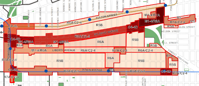
East New York’s rezoning would apply to two distinct neighborhoods – about a dozen blocks in Ocean Hill west of Broadway Junction, and the main portion of East New York and Cypress Hills to the east, bounded generally by Sheffield Avenue to the west, Lincoln Avenue to the east, Fulton Street to the north and Pitkin Avenue to the south.
The move would make room for an undisclosed amount of new development (Vicki Been, when she was at NYU, kept track of the net effects of rezonings during the Bloomberg years, but Amanda Burden’s office did not, and we’re not sure the Department of City Planning under Carl Weisbrod will either), however the Department of City Planning did sketch out what they expect to actually be built as a result.
Without the rezoning, the city expects that only 550 new homes would be built between now and 2030, compared with 7,250 with the rezoning – a net increase of around 7 million square feet of housing. Community facility space would grow by 536,000 square feet rather than 157,000, while the total amount of new commercial space (largely retail) would grow by 1.26 million square feet rather than 669,000 square feet under the current zoning. Industrial space would increase by 153,000 square feet, compared to 126,000 without the rezoning.
Meanwhile, the rezoning would result in 137,000 fewer square feet of auto-related space, 98,000 square feet less of hotel space, and 73,000 square feet less of warehouse and storage space.
The environmental review also assumes that minimum parking requirements, currently in effect for all but the smallest new buildings outside of the Manhattan core and Long Island City (and, to a lesser extent, downtown Brooklyn), would be reformed. The documents don’t go much into detail (there’s also no detail about the inclusionary zoning provisions, other than that it would be mandatory), but they do say that a proposed zoning text amendment “would eliminate off-street parking requirements for low-income housing or Inclusionary Housing within areas that fall within a ‘Transit Zone’,” marked by transit access and low car ownership rates, but without any more specifics.
Talk about this project on the YIMBY Forums
For any questions, comments, or feedback, email [email protected]
Subscribe to YIMBY’s daily e-mail
![]()
Follow YIMBYgram for real-time photo updates
Like YIMBY on Facebook
Follow YIMBY’s Twitter for the latest in YIMBYnews