A consortium of engineers and traffic planners have teamed up on proposals to construct a series of vehicle-free “ribbon” bridges connecting Manhattan to the outer boroughs and New Jersey. The group is led by Samuel Schwartz, former Traffic Commissioner of New York City’s Department of Transportation.
The Queens Ribbon is the first of the new bridges and would connect Long Island City and Roosevelt Island’s Cornell campus to Midtown, Manhattan. The second bridge would connect Brooklyn Bridge Park to Manhattan’s Financial District, while the third and final bridge would connect commuters from New Jersey to either Midtown West, West Chelsea, or Tribeca. The latter has not been specified in regard to on and off ramps in New Jersey and Manhattan.
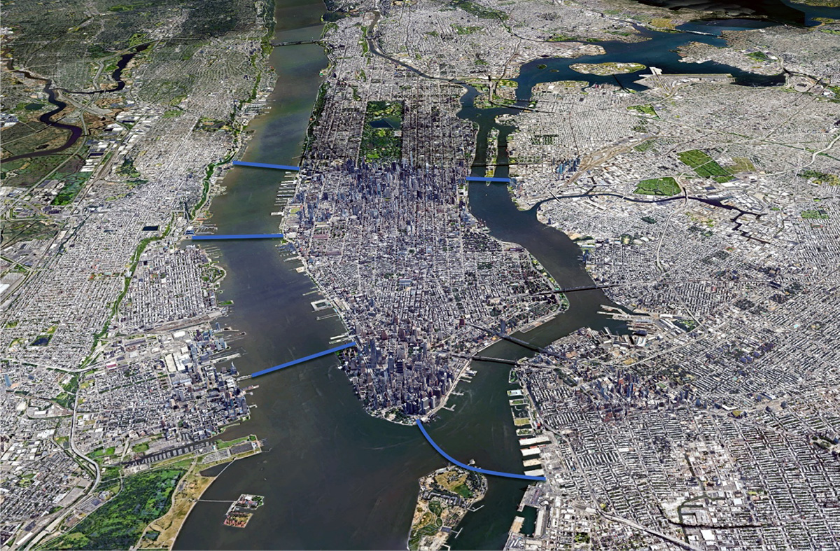
Proposed new ribbon bridges connecting the outer boroughs and possible locations for the New Jersey-Manhattan connections – Sam Schwartz Engineering
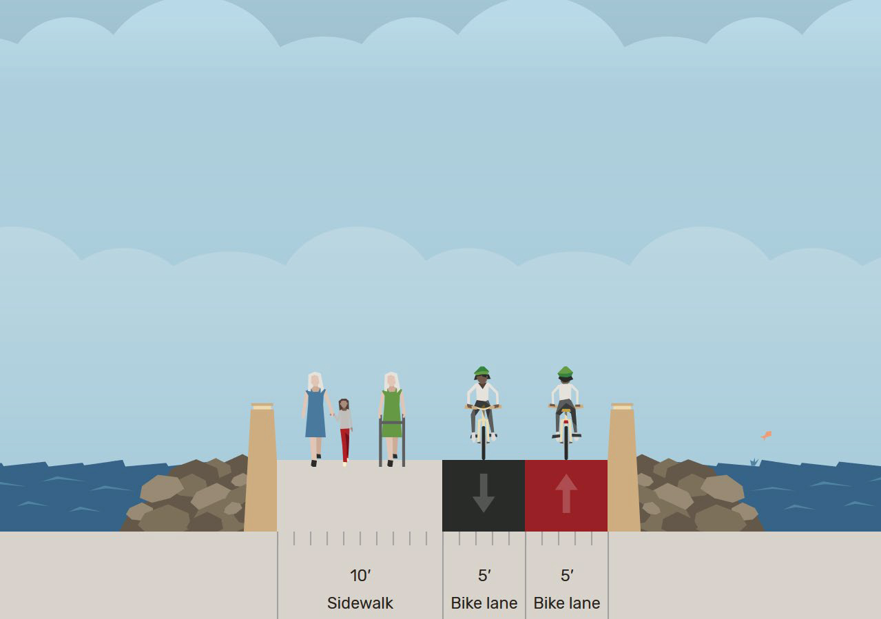
Each of the new bridges would be 20 feet wide and include lanes for cyclists and pedestrian traffic. The current design documents state that each bridge could handle approximately 20,000 people daily. Considering those figures, the three bridges combined could carry the equivalent of 60 subway trains or roughly 50,000 cars per day.

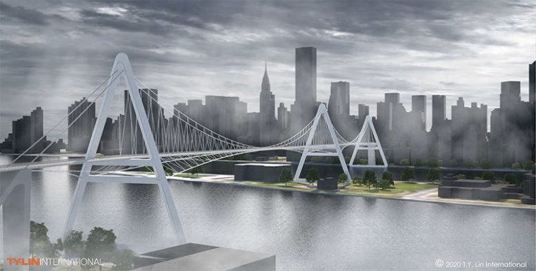
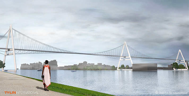
Rendering of Queens Ribbon looking toward Manhattan showing dedicated lanes for bicyclists and pedestrians – T.Y. Lin International
The bridges are referred to as ribbons because of the structures’ minimalist design. Available renderings illustrate a concrete platform that is supported by suspension cables and three delta-shaped towers. The towers are about 300 feet tall and 200 feet wide and are described as a futuristic addition to existing sight lines. Proposals also call for the completion of new street-level bike lanes to facilitate cyclist access.
The estimated construction cost for each bridge is about $100 million, less than half the cost of construction of the High Line, and a fraction of the cost to complete a new subway line.
In addition to Schwartz, New York University’s Tandon School of Engineering and T.Y. Lin International Group, a multinational engineering company, are credited in the proposals.
A thorough environmental review process known as an Environmental Impact Statement would be required before work could begin on the project. It would also require a Uniform Land Use Review Procedure.
Subscribe to YIMBY’s daily e-mail
Follow YIMBYgram for real-time photo updates
Like YIMBY on Facebook
Follow YIMBY’s Twitter for the latest in YIMBYnews




Every word has been screened, no blame and vulgarity on the bridge design: Thank you.
Beautiful, but don’t hold your breath.
Would be a nice donation for some ‘Dotcom’ Trillionaire. Naming rights included.
Good idea, and probably it’s the only way this gets done.
Nice idea that will never happen. If it did, there HAS to be a physical barrier between the bike and pedestrian lanes, because bikers are arrogant SOBs who think they own the road.
Bikers don’t like you either; who kills whom on the road??
Between bikers and pedestrians – bikers are definitely the killers (And yes, I’m both a biker & a ped)
I have mixed thoughts about this project. I won’t say anything else.
I won’t say anything at all. Wait! I just did!
Nice, pretty idea but a $100 million each is a joke. They would end up costing at least $1 Billion each and take decades. So many associates and family members in the suburbs to pay off you know.
The other problem is these are like the current very expensive ferries crossing the rivers. Some people live by the river but most don’t work near the river also. They will always be underutilized for what the taxpayer cost is.
Decent pts. Though the ferries r most cost. The bridgw is fixed cost. Ferries operate at sub 50 percent capacity at new costs ewch trip.
Not to mention the environ impact.
I do wonder the total estimated walk time from queens to nyc. Or nj tonnyc
There is a similar bridge in Nashville, Tennessee.
Fantastic Idea. It would be awesome if it became a reality. NJ would have to split the cost & maintenance.
Split costs? Thats opening a can. Though reasonable.
Wonder da maintain costs? Degumming, patching, ? A median between walkers and bikwrs would hwlp. And double thw width.
Would be perfect for an afternoon toking in the open air. And pretty ppl.
Love it!!!
I wonder which lane scooters would go in? Both, probably, to the peril of pedestrians and the frustration of cyclists.
Thought the same. Hence my rthought of wider foot and bike lanes. No sense in four balls knoxking eqch other across a span.
On paper it seems grand. But applied it would be crazy.
There are issues to surmount including navigation clearances, wind resistance, incline angles and landing sites for the approaches. With the city budget in crisis mode it could be more than 10 years before ground could be broken most likely for the East River side and 20 years for the Hudson versions. The one thing that could change things is the recent emergence of electric assisted and powered bicycles as a mode of transportation.
The architect issues exist. The geeks built it in. Now the real costs wouls be far more.
Ebikes and fam wouls introduce more issues. Speed. Refulation etc. Ie an 8 yr old biker next to wasabi sushi delivery guy.
Naming rights couls subaidize it. The jerry seinfeld on ramp. Or tony soprano last elevator ride ezpanse.
Too narrow for pedestrians, bikes, e-bikes, scooters, and tourists.
First off, can anyone fathom the idea that NYC and and NJ will use “eminent domain” to get the property for the landings for these bridges…to build a bike path, no less?
Second, even if the above were possible, it would take 10 years for the Federal Government to even consider building a bridge over the Hudson River. Keep in mind that the Port Authority had to spend multi-billions of dollars to build a new Bayonne Bridge in order to maintain proper clearance for oversized ships using the Arthur Kill. Just how high…in height and expense (with no tolls)…are the developers willing to go for a foot path?
Speaking of the Port Authority, keep in mind that, under their Federally-mandated charter, passed by Congress, the P.A. is exclusively responsible for all inter-state transportation routes between the two states, and “within a 25 miles radius of the Statue of Liberty” (which, BTW, is why the Tappan Zee Bridge is where it is: less than a mile north of the “25 mile radius.” The P.A. didn’t want to build it, so the State of NY did.
I’m sure this project will give the developers much publicity, hype, and attention, but it’s not going anywhere soon….or at all.
Nice try, though….
U texhnixal weasel.
It would be costly grabbing all dat waterline property. And the height level issues r valid.
How many vessels pass through these pts.
A toll would make sense. Perhaps a bootleg mta turnstile. With a span large enough for a 400lb man. Though such a person walking betwren states is another thing.
Ehat kinda of new tax would be created? A 5 cent parking meter hike?
Or an ecommerce tax on messangers. The land acwuisition would be hell. Some of the access pts would require old smelly city property rights.
What about pottys. As i mean ur speaking of 20k ppl a day? Perhaps a multiple on a sunny day.
In cars one can use a soda bottle when in 15 minute traffic.
I’ve got to dig up my FY1975 NYC Budge wish list and keep it handy for judging this nonsense.
Remember what comes first and makes real sense: the Gateway Tunnel, the Cross-Harbor Tunnel, the replacement for I-278 under the BH Promenade, the MTA deficit, etc.
It’s fun to hypothesize & dream, but this will never happen – nor should it. Not until NYC has made serious progress in developing mega-storm flooding guards. We’ve done pretty much nothing since Sandy to minimize “next flood” havoc. Still, it’s important for NYC not lose it’s ability to dream.
Stopping floods dont matter. Build. Charge. And wait.
Sell or rent the units and then sayu didnt suspect risk. Watwrline property on east xoast is a crap storm ovwr the next 40 yrs.
The hamptons willbe destroyed and the richies will collect their insurance from premiums issued in 1985.
Aunt gertude in new hampshire will barely miss her beighton beaxh or lic or waterfront nyc crib.
Ppl that nuy spaces like this r not primary residents.
It’d be great to bike over to Jersey, load up my draft kings app and place some bets.
A lot to ask, but here’s hoping the interiors begin to approach Beinecke’s Rare Book & Manuscript Library. The bar certainly isn’t too high re surpassing the very disappointing “The Shed” interiors.
Never gonna’ happen.
Its just as logical to building modern day projects with 1400 studios and consolidated operations.
Remember stuy town and coop city and parkchester r nothing more than old world private projects.
And we see nyc seeking to take nyxha property for private housing.
So now u have a private housing annex next to a municpal projecct planning site.
But dont worry the poor xhaps cant find anything cheaper.
So yes
Im saying building a 1000 unit 2 billion dollar site. With 1400k studios and adjusted amount of need based housing.
Nyc owns so muxh bs land that sits doing nothing.
Its not without logic. 1400 studios and 250 parking spots. 250 for dedicatwd parking in nyc is a steal.
Build 5000 sublevel spots with special permitting and u have a secwnt game plan. Get some scum contractor to manage it.
2billion for 1000 units.not too bad.
The land is free. Spend 6 yrs arguing council for rezoning.
Develop a special 21st century nycha 2.0 and move along.
Nyc’s storied heros often lived in ghettos and shamble spaces.
The bowery.
Chelsea.
Hells kitchen.
Harlem.
Les.
Gowanus.
Red hook.
Hells kitchen.
All ghettos.
Now i say a new modern ghetto. Where there r progressive rent increases.
That 76 yr old immigrant paying 432 for a 2 bedroom in hudson yards extended lives next to a 26 yr old paying 2330 for a studio.
Ghettos r nyc.
Huddon yrds is odd. As many of the owners were storagr. Carriage. Etc. Owners with ties dating backing to 1760. Andthe auto body shops.
Thede ppl need to pay off their money.
Underground parking could produce boocoo municipal rwvenue.
Wtf cares if u hav 5000 market rate parkinf apots below a 30 percent affordable houaing slash market rate complex.
Or 30 affordable. And 45 percent higher than affordable rent for the balance of units.
So 1000 for affordable. 1450 for market.
With 5000 parking spots underground. At 250 a spot.
Yes thats a shewt load.but good money.
250 for the weekend crusing car that our significant other eont allow in their driveway?
Separating bike lane from foot path with only a painted line (in a tourist city no less) means bikers will constantly be on the lookout to avoid oblivious sightseers. This sucks for bike commuters and slows trip times considerably. Just look at Brooklyn Bridge. Create some separation on the surface that divides use-case and that also benefits the pedestrian experience.
How in the world would we land airplanes in the river with these structures in place?