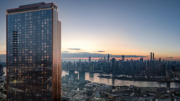
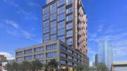
Permits have been filed for two major new towers at 57-28 2nd Street and 1-15 57th Avenue in Hunters Point South. The two proposed, glass residential buildings are being designed by Handel Architects and will sit at the intersection of 57th Avenue and 2nd Street. The sites are located in Long Island City by the Hunters Point South ferry terminal. Both towers are being developed by Gotham and Riseboro Community Partnership.
57-28 2nd Street will yield about 335,000 square feet of space with 452 units spread over 33 stories, rising 360 feet tall. About 6,000 square feet will go towards communal facilities. The mixed-use building will be made out of a reinforced concrete structure and rise up from the 28,700-square foot lot.
1-15 57th Avenue will come with nearly 700,000 square feet of newly built space, climbing 57 stories, and reaching 612 feet into the sky. Within, there will be 692 dwellings. The mixed-use skyscraper will have about 643,400 square feet dedicated towards residential units, nearly 9,000 square feet of commercial space, and around 19,400 square feet for communal facilities. This would be the tallest skyscraper on the Queens waterfront.
No official completion date has been announced yet for the towers, but the impact on the skyline will definitely be substantial when finished.
Subscribe to YIMBY’s daily e-mail
Follow YIMBYgram for real-time photo updates
Like YIMBY on Facebook
Follow YIMBY’s Twitter for the latest in YIMBYnews


Please pardon me for using your space: I have fallen for your reported, not on words but its tower showing. If I am faint I will not see newly designed. (Hello YIMBY)
What at utterly boorish design at such a sublime location. Doesn’t respect the water, interesting shape of land and looks only to maximize residents’ views.
Anything goes apparently in LIC. Please — back to the drawing board!
Dull is cheap and only money matters.
Isn’t the 7 train completely packed at this station during rush hour?
There are several subway lines near here and a ferry terminal. A short ride to Midtown. CBTC was just activated on the 7 and in a few months, the software will get straightened out (L train has a 90% on schedule rate). Bus lanes on the Queensboro Bridge after congestion pricing could absorb riders too. Bike lanes.
I fully understand that this is a rendering, used to highlight the new project. However, the rendering couldnt be further from reality with regards to the existing skyline in Greenpoint as well as Manhattan.
No Williamsburg bridge, a complete lie about the industrial nature of the Brooklyn waterfront. at least 10 existing skyscrapers missing from Brooklyn, the Con ed power plant in Manhattan is missing. No Financial District towers… what is going on here?
I wonder how (if??) the developers/architects are accommodating sea level rise into their plans.
I lived down there when sandy hit, had a foot and half of water in the lobby. Most of the new area that has been built south of that has been shored up and the two new buildings proposed is a little higher ground already so I’d say that they will probably be fine up to sandy + 6-8 feet maybe
Of course. How would anyone overlook that, it’s part of the city zoning as well.
This is the same brilliant thinking that went in to the ConEd plant. They built a flood barrier as high as the previous high storm surge – but Sandy overtopped it.