
City Council Approves Jamaica Neighborhood Plan In Jamaica, Queens
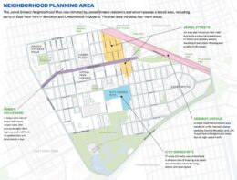
The New York City Council has officially approved the Jamaica Neighborhood Plan, a rezoning initiative led by the Department of City Planning under the Adams administration. Spanning nearly 230 blocks in Jamaica, Queens, the plan will enable the creation of approximately 12,000 new homes, including 4,000 permanently affordable units, making it the largest Mandatory Inclusionary Housing zone in New York City to date. The plan is also expected to support 7,000 new jobs through over 2 million square feet of new commercial and community facility space.